


Barangay Map of the City of Naga
Check out the map links for all 28 barangays of the City of Naga
Physical Features and Environmental Management of the City of Naga
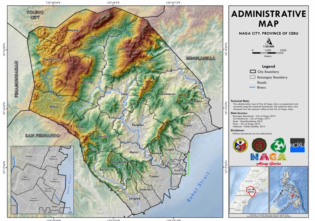
The City of Naga, a third-class component city in the Province of Cebu, is located on the Island of Visayas, Philippines. It is geographically situated at a latitude of 10°12’41” N and longitude of 123°45’30” E. The city is bordered by Minglanilla to the northeast, Bohol Strait to the southeast, San Fernando to the southwest, and Toledo City to the northwest (Map 2.1).
Land Area and Boundaries
The City of Naga spans an official area of 10,197 hectares (ha), as per the approved Department of Environment and Natural Resources (DENR) Barangay Boundary Index Map (BBIM). However, for planning purposes, the city’s total area is taken as 10,498.68 hectares. This figure includes the disputed areas between Minglanilla, San Fernando, and Toledo City (Figure 2.2).
Barangay Distribution and Classification
The city is divided into 28 barangays (Map 2.2), which are further classified into rural and urban categories. Out of these, 13 barangays are considered rural, and 15 are urban (Table 2.1).
Rural Barangays | Urban Barangays |
| Alfaco | Cantaoan |
| Bairan | Central Poblacion |
| Balirong | Colon |
| Cabungahan | East Poblacion |
| Cogon | Inayagan |
| Jaguimit | Inoburan |
| Lanas | Langtad |
| Lutac | North Poblacion |
| Mainit | Pangdan |
| Mayana | South Poblacion |
| Naalad | Tangke |
| Patag | Tinaan |
| Tagjaguimit | Tuyan |
| Uling | |
| West Poblacion |
Barangay Area and Classification Table (2019)
| Name of Barangay | Area (ha) | Percentage (%) | Classification (Urban/Rural) |
|---|---|---|---|
| Alfaco | 610.50 | 5.82 | Rural |
| Bairan | 399.82 | 3.81 | Rural |
| Balirong | 645.92 | 6.15 | Rural |
| Cabungahan | 169.41 | 1.61 | Rural |
| Cantao-an | 820.48 | 7.82 | Urban |
| Central Poblacion | 7.07 | 0.07 | Urban |
| Cogon | 751.32 | 7.16 | Rural |
| Colon | 185.63 | 1.77 | Urban |
| East Poblacion | 20.45 | 0.19 | Urban |
| Inayagan | 368.13 | 3.51 | Urban |
| Inoburan | 200.86 | 1.91 | Urban |
| Jaguimit | 403.09 | 3.84 | Rural |
| Lanas | 658.42 | 6.27 | Rural |
| Langtad | 270.44 | 2.58 | Urban |
| Lutac | 580.84 | 5.53 | Rural |
| Mainit | 221.98 | 2.11 | Rural |
| Mayana | 622.35 | 5.93 | Rural |
| Naalad | 131.99 | 1.26 | Rural |
| North Poblacion | 14.32 | 0.14 | Urban |
| Pangdan | 631.93 | 6.02 | Urban |
| Patag | 303.87 | 2.89 | Rural |
| South Poblacion | 91.23 | 0.87 | Urban |
| Tagjaguimit | 836.89 | 7.97 | Rural |
| Tangke | 175.94 | 1.68 | Urban |
| Tinaan | 381.17 | 3.63 | Urban |
| Tuyan | 276.98 | 2.64 | Urban |
| Uling | 686.22 | 6.54 | Urban |
| West Poblacion | 31.45 | 0.30 | Urban |
Source: CA, 2019
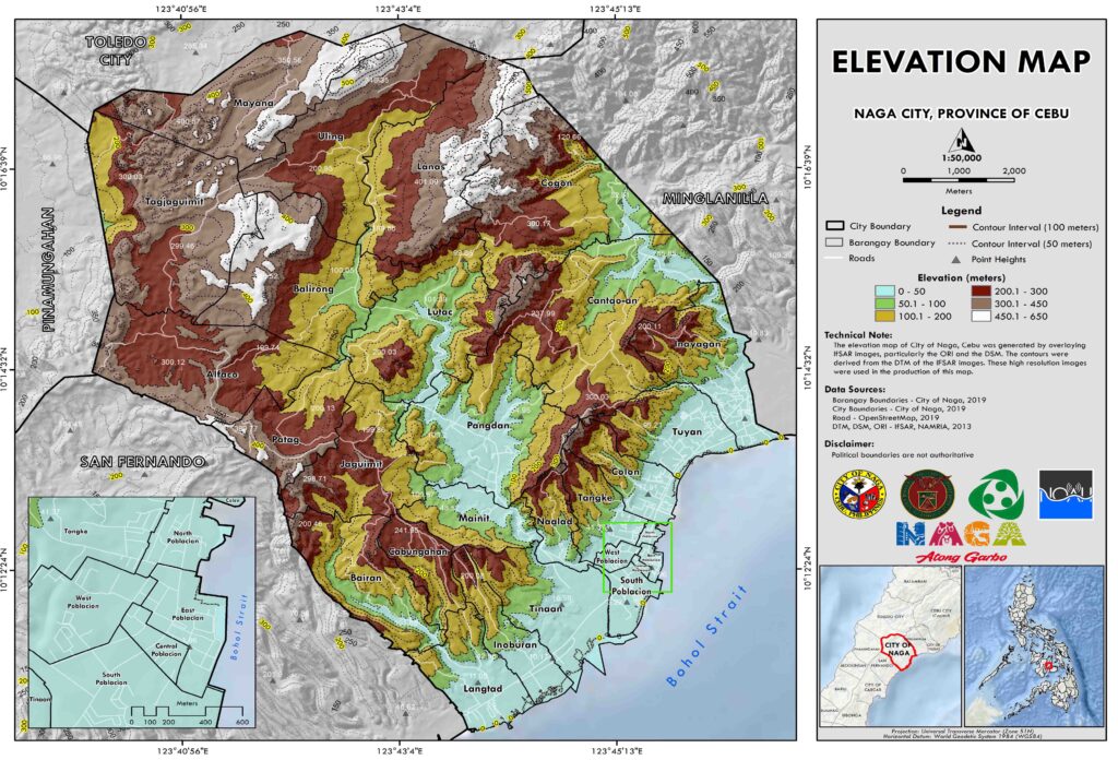
Topography of the City of Naga
The City of Naga, located in the Province of Cebu, features a diverse topography, with an elevation range from 0 to 621.34 meters above mean sea level. This variation in elevation contributes to the city’s natural beauty and plays a crucial role in environmental management and development planning.
Elevation Distribution
Approximately 26.24% of Naga’s total land area lies between an elevation of 100.1 to 200 meters, as shown in Table 2.2. The city’s varied terrain also affects its climate, agriculture, and settlement patterns.
| Elevation (m) | Area (ha) | Percentage (%) |
|---|---|---|
| 0-50 | 1,581.99 | 15.07 |
| 50.1-100 | 1,111.95 | 10.59 |
| 100.1-200 | 2,754.45 | 26.24 |
| 200.1-300 | 2,311.62 | 22.02 |
| 300.1-450 | 2,015.21 | 19.19 |
| 450.1-650 | 723.45 | 6.89 |
| Total | 10,498.68 | 100.00 |
Source: NAMRIA, 2013a
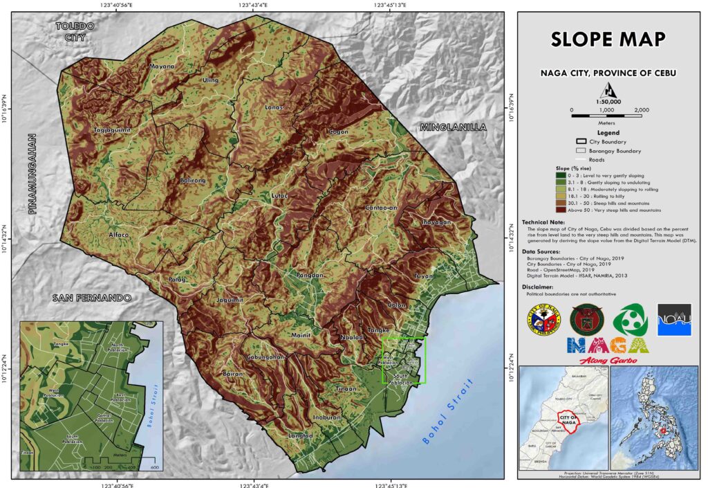
Slope Classification
The slope of the city’s terrain is another significant factor in its land use and development. As of 2013, around 26.56% of Naga’s land area is characterized by steep hills and mountains, as detailed in Table 2.3. These slopes influence the city’s infrastructure development, agricultural suitability, and natural risk factors such as landslides.
| Slope Classification | Percent Rise (%) | Area (ha) | Percentage (%) |
|---|---|---|---|
| Level to very gently sloping | 0-3 | 660.53 | 6.29 |
| Gently sloping to undulating | 3.1-8 | 588.49 | 5.61 |
| Moderately sloping to rolling | 8.1-18 | 1,616.24 | 15.39 |
| Rolling to hilly | 18.1-30 | 2,411.22 | 22.97 |
| Steep hills and mountains | 30.1-50 | 2,788.01 | 26.56 |
| Very steep hills and mountains (Above 50) | Above 50 | 2,434.20 | 23.19 |
| Total | 10,498.68 | 100.00 |
Source: NAMRIA, 2013b